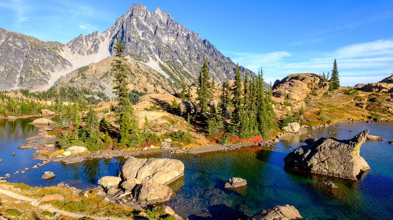
Lake Ingalls is a pristine glacial lake located within the Cascade Range, with Mount Stuart rising behind it. Nevertheless, accessing this breathtaking location isn’t straightforward. There are no roads, only a demanding nine-mile hike up Ingalls Pass. Still, the lake remains a well-visited destination in Washington’s Alpine Lakes Wilderness. You’ll quickly see why once you see its clear, blue waters.
The Cascade Range stretches 700 miles from northern California to southern British Columbia, and it is home to numerous volcanic mountains. Active Mount Rainier is the tallest among them. This mountain, standing at 14,410 feet, is located in the Central Cascades, where much of the region is protected within the Alpine Lakes Wilderness in Washington. This vast area, covering almost 400,000 acres, was shaped by glaciers and now features towering peaks covered in ice and lakes formed from glacial meltwater. Lake Ingalls, situated over 6,000 feet above sea level, is one of these glacial lakes.
It requires significant preparation to get to Lake Ingalls. You will definitely need a vehicle, as even the trailhead is located in a remote area. You can rent a car at Pangborn Memorial Airport (EAT), which is 77 miles away. This small, regional airport only has flights from Seattle. The drive from Seattle-Tacoma International Airport (SEA) is almost twice as long, but it offers nonstop flights to cities around the world. The longer trip would also give you an opportunity to exploreSeattle’s overlooked must-see attractions.
Read more: The Body of Water Frequently Referred to as the Most Hazardous in the United States
Walk the Ingalls Way Trail
The Lake Ingalls Trailhead is located at the end of NF-9737, a rugged, dirt road that spans the last eight miles of the journey from either direction. Along the route, you’ll encounter additional trailheads and a campsite, with a parking area at the road’s conclusion. From there, the Ingalls Way Trail starts. This is a nine-mile trail that goes out and back, gaining almost 3,000 feet in elevation. You should expect it to take a minimum of six hours. Additionally, you must buy a Northwest Forest Day Pass ($5) online prior to beginning your hike.
This path can be misleading. It starts on the Esmeralda Basin Trail, a simple and well-kept route that winds through a valley covered in trees and blossoms. Within just a half mile, you’ll come to a crossroads with Ingalls Way. If you take the right turn onto this trail, you’ll immediately begin ascending. It’s quite misleading. Ingalls Way quickly moves away from the woods and flowers. The trail features switchbacks as it climbs along a rocky route. A second intersection, this time with Longs Pass, will be on your right. Continue straight ahead and keep climbing. You’re nearly at Ingalls Pass.
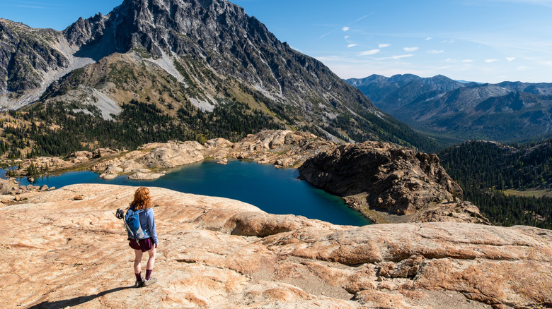
That’s where you’ll see Mount Stuart for the first time. While many of the peaks in the Cascades are volcanic, this is the second-highest mountain in the range that isn’t. It is covered in glaciers, including Sherpa, Ice Cliff, and Stuart Glaciers on its northern side. Lake Ingalls is located directly beneath it.
Take the trail that circles Lake Ingalls
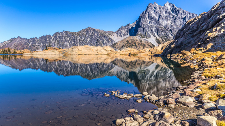
It’s difficult not to pause and take in the view when you first encounter Lake Ingalls. The clear blue water, framed by rugged mountain peaks, is truly stunning. Ingalls Pass splits into two paths that lead down toward the lake. The right path is more direct but steeper, while the left trail winds into the mountainside. You might not be surprised to spot mountain goats along the way.
You can stroll directly to the lake’s shoreline, which features a sandy base with big rocks scattered throughout. The water remains, as expected, consistently chilly. Additionally, there’s another path that loops around the lake. This could add more distance to your already lengthy hike, but the mountain scenery is definitely worth the extra effort. At least this trail is fairly level, and you’ll probably be pausing often to capture pictures. Eventually, as it’s an out-and-back route, you’ll retrace your steps along Ingalls Pass back down the mountain. The way down is significantly easier than the ascent.
Since you’re already in this remote area of Washington, you should check out MathHotels.com for more information about the Alpine Lakes Wilderness. If you’re heading back towards Seattle, Snoqualmie Pass is aa modest coastal town offering amazing winter outdoor experiences. Then, just past it, the well-known Snow Lake Trail isan underappreciated substitute for Mount Rainier. Although this trail isn’t even close to being difficult, it leads to another stunning glacial lake. Fortunately for you, the Cascades appear to be filled with such places.
Eager to uncover more secret treasures and professional travel advice?Sign up for our free email newsletterfor entry to the world’s most closely guarded travel insights. You can alsoAdd us as a preferred search provider on Google.
Read the original article on MathHotels.com.